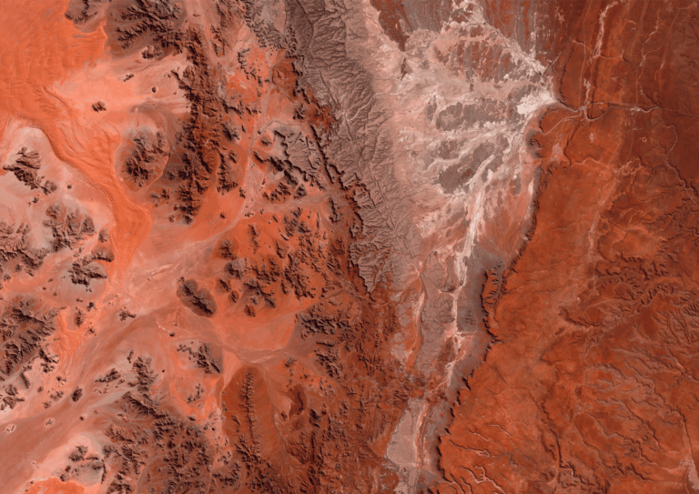
In the heart of Chile’s Atacama Desert, one of the driest and sunniest places on Earth, stands Cerro Dominador, the first solar thermal power plant in Latin America with thermal storage capacity. This innovative solar complex combines two technologies: concentrated solar power (CSP) and photovoltaic (PV) energy, with a total capacity of 210 megawatts and an estimated lifespan of 30 to 50 years.
Its most iconic structure is a 252-meter tower, the second tallest in the country, surrounded by 10,600 heliostats (movable mirrors) that track the sun throughout the day. These mirrors reflect sunlight toward a receiver at the top of the tower, where a special blend of molten salts is heated to over 500 °C. This heat is stored and used to produce electricity even at night or on cloudy days, with up to 17.5 hours of energy autonomy.
Optical Satellite Applications in Solar Projects
Before Construction – Strategic Planning
During the early stages of solar project evaluation and design, optical satellites provide essential insights:
- Site selection: Satellite imagery helps analyze land use and avoid protected areas, bodies of water, steep slopes, or unstable ground. It also ensures enough space is available for heliostats and PV panels.
- Accessibility analysis: Assessment of existing or potential access routes for machinery, materials, and personnel. Terrain evaluations help identify logistical challenges without site visits.
- Monitoring the natural environment: Detection of vegetation changes or soil erosion that could impact the project. Historical imagery archives (10+ years) enable the study of natural threats like landslides or sedimentation.
During and After Construction – Monitoring & Maintenance
Satellite imagery supports efficiency and safety:
- Construction progress tracking: Visual monitoring of the build-out over time. Satellite images allow comparison between as-built structures and the original plans to detect delays or deviations.
- Operational condition control: Visual evaluation of plant integrity and condition of PV panels and heliostats through photo interpretation. Ideal for spotting potential failures or damage.
- Infrastructure and surroundings supervision: Review of access roads, transmission lines, and maintenance areas from above.
- Detection of unauthorized activity: Identification of unexpected movements, structures, or vehicles in restricted zones to support security efforts.
- Digital Elevation Models (DEMs): Generation of terrain models for planning maintenance, upgrades, or expansion without on-site surveys.


Satellite monitoring of the plant
Satellite monitoring of the plant
- Continuous monitoring with no site visits: High-resolution satellite imagery enables efficient remote supervision, saving time and money.
- Early issue detection: Identify risks or damage before they escalate, protecting your infrastructure and investment.
- Optimized decision-making: Insights from image analysis and photo interpretation allow smarter operations and maintenance strategies.
- Long-term monitoring: Satellites provide ongoing visibility throughout the 30–50-year lifespan of the plant.
A Clean Energy Future, Visible from Space
Projects like Cerro Dominador show that the path to clean energy can go hand in hand with cutting-edge Earth observation technology. Optical satellites enable us to monitor large-scale energy infrastructure from a privileged perspective, reducing costs, improving decisions, and enhancing performance throughout a plant’s lifecycle.
And they offer something truly unique: the ability to witness thousands of mirrors moving in synchrony with the sun, a visual testament to the intelligent harnessing of solar energy.
Thanks to our own satellites, together with our partners, we deliver high quality imagery and analytics for high impact insights which result in improved decision making.